Weather Forecast
Introduction
Understanding the weather forecast is a massive subject that deserves more time than a brief blog. Instead I have decided to split this into 3 separate blogs. My goal with this blog is to breakdown some of the areas to give you information to help your understanding. I have split it into the following:
- Part 1: Making a weather forecast?
- Part 2: What do those clouds mean?
- Part 3: Why is the weather different on the mountains?
This should help you to go straight to the area or areas that interest you most.
Part 1: Making a weather forecast
Why?
Surely it would be easier just to use a weather forecast that has already been made?
Absolutely you can do that and there are quite a few to choose from. Ones that I have used include:
These sites give some great information on what the weather might be doing. Each one though is a person’s or peoples’ views on how they read the weather chart. Why shouldn’t that person be you?
Understanding how to make your own weather forecast can be the difference between a good day out and a great day out. It can help you decide where to go, what side of a hill is best to walk up, what equipment you may need and so much more.
Knowing what the weather is going to do from someone else’s views is great. Actually understanding what is happening and why is priceless!
What gives me the right to write this blog?
As a qualified Mountain Leader through Mountain Training I have been through rigorous training, consolidation and assessment to qualify me to do what I do in the outdoors. Part of this is building up knowledge of weather and weather forecasts.
Before I started the Mountain Leader journey I didn’t have the first clue of how to read a weather forecast. I just followed what I was told on a forecast. I didn’t even know about the impact that height gain can have on weather systems.
For my Mountain Leader training and assessment I chose to go to Graham from Graham Uney Mountaineering. In the training course it was Graham who first introduced me to the idea of making my own forecast from the information available. Yes Graham, you are to blame for me going full weather geek!
I was then fortunate enough to attend a Met Office weather workshop. This was led by qualified meteorologists.
My interest was most definitely furthered……………
I now do my own weather forecasting. I then check my findings against the above sites to compare. This gives me a great understanding which can help me when delivering Rock Climbing, Hill Walking or Navigation Training experiences
Where do I start
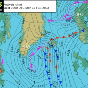
Let’s start by looking at a synoptic chart:
At first glance a synopic chart can be a very confusing thing. This one is taken from the Met Office website on Sunday 02/02/2023. Once we understand it, we can understand more about what will happen with our weather.
So what are the different symbols on the chart?
- x – this shows us the centre of the pressure area
- L – this tells us it is an area of Low pressure
- H – this tells us it is an area of High pressure
- Numbers – This tells us the volume of air pressure
- Black lines – these are Isobars. Lines that join areas of equal pressure
- Red lines with red semi circles – Warm weather fronts
- Blue lines with blue triangles – Cold weather fronts
- Purple lines with semi circle and triangles – Occluded weather fronts
Low Pressure v High Pressure
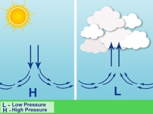
Our atmosphere creates pressure on the earth’s surface. Areas of high and low pressure occur as the air ascends or descends. As the air warms up it begins to ascend. This leads to LOW pressure at the earth’s surface. As air cools it begins to descend. This leads to HIGH pressure at the earth’s surface.
To think about what impact low or high pressure has I like to picture a box with a lid.
HIGH pressure pushes down on the lid of the box. It keeps the contents calm and safe and stops anything else interfering and causing issues.
LOW pressure lets the lid off the box. This means that the contents are disturbed and influenced by everything around them.
To get slightly more technical, as HIGH pressure involves the air cooling, this means it is dropping in height. This in turn means there is less chance of clouds forming, hence why the weather tends to be better. The opposite can be said for LOW pressure. The air is warmer, meaning it gains height. As it cools it begins to form clouds, hence why we tend to experience more unsettled weather.
Hence why areas of HIGH pressure tend to bring times of settled weather and areas of LOW pressure tend to bring times of unsettled weather.
Hopefully this picture helps with that understanding
So, to bring this back to our synoptic chart:
- If you see HIGH pressure on the synoptic chart, keep your fingers crossed, should be a good clear day. Although in winter will be rather cold!
- If you see LOW pressure in the synoptic chart, get your big coat, your wellies and don’t even think of hanging the washing outside to dry!
Numbers
1016, 1024, 986, 1000 ahhhhhhhhhhh what do they mean???
If we want to get technical these are measurements of pressure. Those measurements are called HPas or HectoPascals. They are more commonly know as Millibars.
Much like the contour line on a map shows the same height all the way along the line, the line on a synoptic chart shows the same measurement of pressure all the way long that line.
A number over 1022 HPA is usually considered as HIGH pressure, Anything under that is usually considered as LOW pressure
The Black lines
These lines are isobars. They lines join areas of equal pressure.
When I see these lines on a synoptic chart I use them as a way of telling me how strong the wind will be.
If we look at Scotland in the above image.
As a rule of thumb each line equates to winds of 5mph. We can see that there are only 2 lines crossing Scotland and the Scottish Isles. That means that, in this example, we can expect winds of up to 10mph.
Also, in areas of LOW pressure, the wind blows in an ANTI-CLOCKWISE direction and in an area of HIGH pressure, the wind blows in a CLOCKWISE direction. This information can prove valuable to be able to make decisions on which side of a hill to stay on to escape the wind
For a visual we can also see that there are larger spaces between some lines and smaller spaces between others. The smaller the space means the stronger the winds. So in an area where the lines are closer together we can expect stronger winds and gusts.
So again, looking at this example, we can see that, In Scotland the lines are closer together, whilst in England they are further apart. This means we can expect lighter winds in England that day.
Red Lines, Blue Lines and Purple Lines
The different coloured lines and their shapes represent weather fronts.
A weather front is a boundary between 2 air masses (different types of air).
“Air masses? I thought we were talking about weather fronts Sean?” I can hear you asking. In order to understand what a weather front is, we need to know what causes it.
‘An air mass is a large volume of air in the atmosphere that is mostly uniform in temperature, pressure and moisture’ – National Geographic
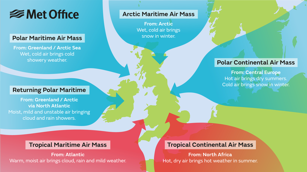
In the UK we are affected by 6 main air masses. These are:
- Arctic Maritime
- Polar Maritime
- Returning Polar Maritime
- Tropical Maritime
- Tropical Continental
- Polar Continental
See picture below
Continental = originates over the land
Maritime = originates over the sea
Arctic, Tropical and Polar shows the region of the world in which they form
As you can see from the above picture, the United Kingdom is rather unique when it comes to weather.
- We are in a location where we can be affected by both cold air from the north and warm air from the south
- We are an island so are also affected by air that both:
- Comes to us over land so tends to be drier, and,
- Comes to us over the sea so picks up moisture
As these air masses come together you get a reaction. This reaction is called a weather front and tends to involve a band of rain in some form.
Still with me? 🙂
Remember those red lines, blue lines and purple lines? Let’s talk more about them now:
- Red lines with semi circles indicate a warm front coming
- Blue lines with triangles indicate a cold front coming
- Purple lines with both shapes indicate an occluded front coming
Cold Front
The above image shows a cold front ,catching up with a warm front. As cold air is heavier than warm air it forces itself underneath the warm air. This forces the warm air to rise rapidly and, therefore, cool rapidly. This rapid cooling causes clouds to build more rapidly into towers, therefore bringing heavy busts of rain.
This can be followed by lots of clouds and other short bursts of rain. Can also cause hail and thunder.
We will talk more about the actual clouds in Part 2.
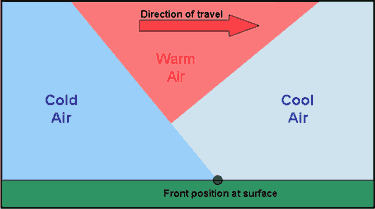
Warm Front
The above image shows a warm front catching up with a cold front.
As the air is warm and lighter it tends to gradually go over the top of the cold front. As with all air, when it reaches height it beings to cool and turn into clouds. Due to how high over the cold front it is, we first start to see very high “whispy” or “mare’s tails” clouds known as Cirrus. As the air gets cooler still and lower down these clouds become more substantial until they tend to turn into long flat layers of rain clouds called Nimbo Stratus. (More on that in Part 2)
Occluded Front
The above image shows an occluded front.
As you can see, the cold front has caught up with the warm front. This is because cold fronts tend to move quicker. You will also notice that the warm front is pushed up. As the cold front pushes the warm front up, it catches up with the other cold front. This then causes that warm front to be trapped in a narrow corridor and therefore creates a narrow band of rain that can be quite heavy.
Due to the merging or various fronts, occluded fronts can be unstable and bring varieties of weather – never usually good weather though!
Weather Forecast – End of Part 1
Thank you for taking the time to read this blog. I hope you have both enjoyed it and also found it useful!
I have really enjoyed putting it together as weather is something that I really enjoy learning and teaching about.
Parts 2 & 3 will follow in due course.
Questions and comments are always welcome as they enable me to improve the information I share with you.
If you would like to see other topics in one of my blogs feel free to get in touch by clicking here


